Showing posts with label Tourist Destination. Show all posts

SIARGAO ISLAND BASIC INFORMATION AND TUTORIALS


SIARGAO ISLAND - THE MYTH, THE LEGEND, THE TRUTH
Where Is Siargao? How To Get To Siargao?

Siargao Island
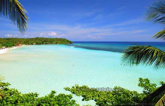
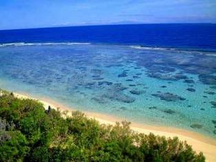
Off the northeastern tip of Mindanao lies the teardrop-shaped island of SIARGAO, a largely undeveloped backwater with languid beaches, dramatic coves and lagoons battered by the Pacific Ocean and a verdant hinterland of rustic little barrios and coconut groves.
Resulta ng larawan para sa siargao island map
Some of the first tourists here were surfers, who discovered a break at Tuason Point that was so good they called it Cloud Nine, and though it’s still off the tourist trail, word of mouth is bringing an increasing number of surfers from around the world.

Arrival and getting around
Most visitors arrive by ferry at Dapa, 16km from the modest but comfortable resorts around the island’s friendly little capital of General Luna, known as GL, on the east coast. There are no banks and credit cards aren’t accepted in most places, so bring cash.

Your choices for getting around the island are fairly limited. Most locals use the habal-habal (motorcycle) drivers, good for up to two people and light luggage. Rates are fixed: Dapa to Cloud 9 is P200, while Dapa to GL is P150. Rides between GL and Cloud 9 should be P15. Drivers will take you to Magpupungko for P300 or the Tak-Tak Falls near Burgos for P1000; in both cases the price includes the trip back. If you intend to do a lot of roaming around, ask your accommodation about renting a motorcycle (P500/day).
Resulta ng larawan para sa siargao island cloud 9
The other options are tricycles and minivans: tricycles will charge at least P30 per person (P150/vehicle) between Dapa and GL, but sometimes ask for a lot more (it depends on how much commission they are expecting from your hotel). Minivans charge P300 per person or P1500 per trip to the airport – other trips will be charged according to time and distance. For bangka trips see opposite.

Accommodation
Accommodation in Siargao covers the whole range, from modest lodges aimed at backpackers and low-budget surfers, to upmarket tropical resorts. Most accommodation is a short distance from GL, and can help arrange motorbike rentals, bangka trips and other forms of transportation.

Exploring the island of Siargao
Resorts line the coast north of GL, and though there isn’t really a beach here it’s a lush laidback strip, with swathes of coconut palms linked by a sand road. The whole area is generally referred to as Cloud 9, though the world-renowned break is actually at Tuason Point, 2km north of GL, towards the end of the hotel strip.

The peak surf season is September and October, while things tend to slow down at the end of the year; beginners will find the weaker surf in June and July more manageable. Even if you don’t surf, wander out to the viewpoint at the end of the Cloud 9 boardwalk, a rickety wooden pier that cuts across the lagoon to the edge of the biggest waves.

Some 35km north of GL via mostly dirt road is PILAR, a village of traditional wooden stilt houses on the edge of the mangroves. It’s best known for Magpupungko Beach, 2km further north and the site of regular beach parties every Friday night (P20). The sandy beach is one of the island’s best, but the highlight is the giant natural swimming pool (basically a huge rockpool) that forms to the far left of the beach at low tide.

The water is beautifully clear and inviting, assuming the weather cooperates. There’s a nominal charge of P50 per person, but this isn’t always enforced. Minivan drivers should take you for P2000–2500 (1hr). It’s a long and bumpy ride by motorcycle.

Siargao island-hopping
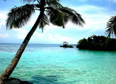
The seas around Siargao are littered with unspoiled and rarely visited islands, but you’d need your own boat and lots of time to explore them all. The easiest to visit are the three islands just off the coast of GL (around 30min by bangka): day-trips to all three cost P1500 or P2500 depending on the size of the boat. Most resorts can fix you up with local bangka operators.

Naked Island is little more than a giant sand bar and perfect for lounging in the sun. Dako Island is the largest of the three, smothered in coconut palms and home to a small fishing community. The villagers will happily serve you fresh coconut (P20) or even barbecue chicken (P150) if required. Tiny Guyam Island comes closest to the stereotype of a classic desert island, a circular clump of sand and palm trees ideal for picnics, swimming or sunbathing.
Resulta ng larawan para sa siargao island naked island
The island caretaker usually charges a fee of P10 per person. Snorkelling isn’t much good off any of these islands – the best reefs lie in between them, so ask your boat to make an extra stop. Another appealing day-trip from Siargao is to La Janoza and Mamon, the easternmost islands in the archipelago – the bangka ride takes around one hour and costs around P3500 per boat.

There’s a powdery white sand beach and a quaint fishing village on La Janoza and between the two islands is a pellucid lagoon that’s wonderful for swimming and snorkelling; both islands are also surfing hotspots.

CAMOTES ISLAND CEBU TOURIST DESTINATION GUIDE BASIC INFORMATION AND TUTORIALS


The Camotes Islands

About 30km northeast of Cebu City, the friendly, peaceful Camotes Islands, which once sheltered Magellan’s fleet, are gradually opening up to tourism, with fast boats from Cebu now bringing them within a couple of hours of the city.

The two principal islands, Poro and Pacijan, are linked by a causeway, which makes exploring by motorbike an appealing prospect.

The main town on Pacijan is San Francisco, but most of the resorts are on the beaches of the northwest and southwest coasts. In the north beyond Lake Danao, Tulang is a picturesque islet lapped by turquoise waters, which has good snorkelling and diving.

Over on Poro you can pay P10 to swim in a series of small underground caves in Bukilat, while easier swimming awaits at Busay Falls just a short walk from Tudela on the south coast. To get the lay of the land head up to Arquis Viewing Deck on Pacijan.

From here you can see Lake Danao, site of Greenlake Park where you can take sakanaw (local boats; P500 for a 10-person boat) trips out to the mangroves.

Arrival and information
The Oceanjet fast ferry departs for Poro daily from Cebu City Pier 1. There are also daily bangkas and Supershuttle Ferry (T0928/371-3113) services from Danao to Poro and Consueles on Pacijan. Poro is also linked by public bangkas from Mandaue. Hiring a motorbike (P500/day) is the easiest way to get around, while short trips on a habal-habal cost P50. The easternmost (and smallest) Camotes island, Ponson, can be reached by small bangka from Poro. There’s a tourist information desk and post office at the town hall in Poro, but there are no banking facilities anywhere in the Camotes, so bring enough cash to last.

Accommodation and eating
For food, the better restaurants are mostly in the resorts, but the Green Lake Restaurant on Lake Danao does delicious tilapia. Keshe Beach Resort In the northwest of Pacijan Island, next to Borromeo T0929/892-5792.

Situated on beautiful Bakhaw Beach, Keshe has
attractive simple nipa huts.

2 Mangodlong Rock Resort Heminsulan on Pacijan Island T032/345-8599, Wwww.oceandeep.biz. Sister resort to Santiago Bay, Mangodlong has rooms set in a coconut plantation overlooking the beach, plus a dive centre.

4 My Little Island Hotel In Esperanza on Poro Island T032/497-095 Wwww.mylittleislandhotel .com. The best rooms on Poro, and a pool (P75 for non-residents), but it’s not on the beach. 4

Santiago Bay Garden and Beach Resort In the southwest of Pacijan Island T032/345-8599 Wwww.camotesresorts.com.ph. Great views and comfortable a/c rooms with cable TV. 3

OLANGO ISLAND CEBU TOURIST DESTINATION BASIC INFORMATION


Olango Island Cebu

Five kilometres east of Mactan Island, Olango Island supports the largest concentration of migratory birds in the country. About 77 species, including egrets, sandpipers, terns and black-bellied plovers, use the island as a rest stop on their annual migration from breeding grounds in Siberia, northern China and Japan to Australia and New Zealand.

Declared a wildlife reserve in 1998, the island is also home to about 16,000 resident native birds which live mostly in the northern half; the southern half of the island is made up of a wide, shallow bay and expanses of mud flats and mangrove.

The reserve is at its best during peak migration months: September to November for the southward migration and February to April northbound.

Most resorts on Mactan can organize a day-trip here, though you could visit independently: there are hourly bangkas (P40) to Santa Rosa on Olango Island from the wharf near the Hilton on Mactan Island or you can hire your own bangka from the area around the Tambuli Beach Resort for around P2000 to the island and back.

From the small Santa Rosa wharf it’s only a short tricycle ride to the sanctuary. If you want a knowledgeable guide, make arrangements with the Coastal Resource Management Project of the Department of Environment and Natural Resources (T032/346-9177) located in the Capitol Building in Osmeña Boulevard in Cebu City, which runs an Olango Birds and Seascape tour.

Jump Off Point Outfitters (T032/236-5678, Ejump_offpoint@yahoo.com) can also arrange kayak trips to Olango and Sulpo islands. The only place to stay is the lovely Nalusuan Island Resort & Marine Sanctuary (T032/516-6432, Wwww.nalusan.mencaresorts.com; 5), a wonderful place on an islet rising out of Olango’s western coastal reef with rooms and duplex cottages on stilts in the water.

The open-air restaurant specializes in seafood caught on the doorstep and there are nightly campfire cookouts where you can barbecue food as you like it. The resort can collect you in Mactan if requested in advance and there are kayaks available to explore the area.

APO REEF MARINE PARK MINDORO OCCIDENTAL TOURIST DESTINATION BASIC INFORMATION


Apo Reef Marine Natural Park

Lying about 30km off the west coast of Mindoro, Apo Reef stretches 26km from north to south and 20km east to west, making it a significant marine environment. There are two main atolls separated by deep channels and a number of shallow lagoons with beautiful white sandy bottoms.

Only in three places does the coral rise above the sea’s surface, creating the islands of Cayos de Bajo, Binangaan and Apo.

The largest of these, Apo, is home to a ranger station and a lighthouse. The diving is really something special, with sightings of sharks (even hammerheads), barracuda, tuna and turtles fairly common.

Most of the Philippines’ 450 species of coral are here, from tiny bubble corals to huge gorgonian sea fans and brain corals, along with hundreds of species of smaller reef fishes such as angelfish, batfish, surgeonfish and jacks.

If you’re not staying at the Pandan Island Resort, you can head to the reef on one of the liveaboard trips offered by many dive operators in Coron Town (in Busuanga; see p.377) or Manila.

Alternatively the Sablayan Eco-Tourism Office can organize a 10-person boat out to the reef for P6500. However you get here, to snorkel on the reef you need to pay a fee of P350, or P1300 to dive.

PHILIPPINE EAGLE AND NATURE CENTER DAVAO CITY PHILIPPINES


Philippine Eagle Research & Nature Center in Davao City, information sheet.

To view the largest eagles in the world (in terms of their 7ft wing span), head to the  Philippine Eagle Center (PEC;   %082-224 3021; www.philippineeagle.org;  adult/child P100/50;   h8am-5pm), which is dedicated to conserving this  endangered species.

Also known as monkey-eating eagles, these birds, with an  average lifespan of 20 years in the wild (longer at the centre), are threatened by  deforestation and hunting. About 500 remain in the wild in the Philippines and  around 20 of the 35 here were bred through artificial insemination. The complex is  set in a lush pocket of native forest near Malagos, 36km north of Davao.

There are  other wild birds flitting around and other animals, including the Philippine brown  deer and Philippine warty pig. Volunteer guides are around to answer questions.  To stay overnight in the area, try the collection of cottages at Malagos Garden  Resort (   %0917 625 2467, 082-221 1545; www.malagos.com; dm per person  P350, q from P2400;   a), set in a large landscaped property with gardens, walking  paths, a bird park and a butterfly sanctuary.

Dr Bo, a veterinarian who owns  Malagos with his wife Olive, and known as 'the bird whisperer', runs his own eagle  (mostly serpent and fishing eagles) rehabilitation center and puts on a 'bird show' (P125) every Sunday at 10.30am (in good weather).

Tents for large groups are  provided for those interested in camping (P350) and nonguests can visit for P100.  Popular with corporate retreats and weddings and the like. Easy to find, around  300m before the Eagle Center.

How to get to Philippine Eagle and Nature Center?
 From Davao, catch a bus to Calinan (P45, one hour) from the Annil Terminal  across the street from Bankerohan Public Market. Though decrepit, the bus is still  a more comfortable option than a jeepney (P45).

The latter leave from in front of  Ateneo University across from the Marco Polo Hotel. In Calinan, grab a motorcycle  or tricycle uphill to the research center or Malagos (P20, 10 minutes). A taxi from Davao runs around P400 one way.

HOW TO GET TO SIARGAO BASIC INFORMATION


Information in going and around Siargao.
 
Air 
Cebu Pacific has daily (50 minutes, 12.45pm) direct flights between Cebu and Siargao’s Sayak airport near Del Carmen. Another option is to fly from Manila to Surigao and connect by boat from there. A few habal-habal (motorcycle taxis) wait outside the airport’s gates for arrivals; however, it might be more convenient to arrange transport in advance with your accommodation.

Boat 
Three early-morning boats leave from Dapa to Surigao (all departure times are approximate): 5.30am is a small, local-style bangka; the 5.45am Fortune Angel (2½ hours) with an indoor air-con cabin is most recommended; the 6am Montenegro lines boat is a roll-on, roll-off (RORO) ferry. The 10.30am boat is the slowest.

You can purchase tickets (P270) the morning of departure. The early-morning boats allow you to connect to flights in Surigao or travel by bus to Cagayan de Oro and Davao in a single day (these would be long, tiring days); however, it means leaving Cloud Nine extremely early. Arrange a motorcycle to Dapa through your accommodation. Bangkas to Socorro on Bucas Grande leave from the municipal wharf next to the main one.

Getting Around Siargao
Jeepneys run from Dapa to GL (one hour); a better option is to hop on a habal-habal (motorcycles large enough to seat more than one passenger with bags and usually jerry-rigged with a canopy to guard against the elements) to GL or the nearby resorts (P100 to P200, 20 minutes) or Cloud Nine (P150 to P300, 30 minutes).

Price depends on your negotiating skills and time of day (early morning Getting Around Jeepneys run from Dapa to GL (one hour); a better option is to hop on a habal-habal (motorcycles large enough to seat more than one passenger with bags and usually jerry-rigged with a canopy to guard against the elements) to GL or the nearby resorts (P100 to P200, 20 minutes) or Cloud Nine (P150 to P300, 30
minutes).

Price depends on your negotiating skills and time of day (early morning trips always P300). Tricyclescost nearly the same but are much slower. A great way to spend the day is to tour the island on your own (the majority of the 'circumferential road' is now paved); the going rate for motorcycle hire is around P300 for half a day to P500 for the day.

DAVAO CITY PHILIPPINES BASIC INFORMATION AND TUTORIALS


What to expect in Davao.

This sprawling city, the culinary, cultural, economic and commercial capital of the  south is, for better or worse, becoming more like Manila. More traffic, more malls,  more multinationals, more subdivisions hidden behind security gates.

However,  Mt Apo looms majestically in the distance symbolising the typical Davaoeños dual citizenship as both an urbanite and someone deeply rooted to the land outside the  city. Locals know Davao (dah-bow, and sometimes spelt ‘Dabaw’) has more than  enough action to keep them satisfied, and yet it’s only a short drive or boat ride to  forested slopes and white-sand beaches.

Able to hold out against the invading Spaniards until the mid-19th century, the  city is an interesting mix of Muslim, Chinese, tribal and even Japanese influences – the latter because of early abaca-processing warehouses in the area and less happily because of WWII.

Predominantly Christian, the city has seen its share of hard times, especially in the 1980s when there was guerrilla fighting in the streets.

These days there's also a significant number of South Indians, many studying at  Davao Doctor's Hospital; but there are few Korean expats, it's said because of the  city's strict anti-smoking laws.

While Davao continues to expand, especially south towards Toril, much of the  land outside the city has been turned over to massive plantations growing export  quantities of pineapples, bananas and citrus.

BORACAY PHILIPPINES BASIC INFORMATION AND TUTORIALS


While only 7km tall and at its bikini line 500m wide, tiny Boracay has rapidly  become the Philippines' top tourist draw, fuelled by explosive growth and a  tsunami of hype; in 2013 the readers of Travel & Leisure voted it the second-best  island destination in the world after Palawan.

The centre of the action is dreamy  White Beach, a 4km, postcard-perfect stretch of sand lined from one end to the  other with hotels, restaurants, bars, and dive shops now several blocks deep.

The  beach path is typically awash with visitors, including large groups of package  tourists drawn from all over Asia – most commonly Korea, Taiwan and China. The  ocean is full of romantic paraws (an outrigger sailboat) giving rides; colourful  parasails fill the air. After perfect sunsets, live music breaks out, and firedancers  twirl their batons.

The party goes on all night. All of this can be great fun, à la  Waikiki, and can easily occupy your entire visit. Just don't expect the Boracay of 30  years ago, when visitors revelled in the fact that their dirt-cheap nipa hut had no  electricity.

Beyond White Beach the island continues to undergo unchecked growth. New  multimillion-dollar properties rub shoulders with tin shacks. Construction  continues on the massive Newcoast development, a planned community aping  Santorini, Ibiza and other brand locations, which has swallowed 14% of the island.

If you're looking for authenticity, however, you can still find it. Head north to  peaceful Diniwid Beach for a break in the action, or east to Bulabog Beach, home  to the local watersports crowd, with its welcoming community vibe. All things  considered, Boracay is a place where you can find whatever you want if you know  where to look. Otherwise, grab that weng weng cocktail, sink into your waterfront beanbag chair and just marvel at the spectacle of it all.

BILIRAN ISLAND BASIC INFORMATION AND TUTORIALS


HOW TO GET TO BILIRAN ISLAND AND WHAT TO EXPECT IN BILIRAN ISLAND?

The beautiful and largely undiscovered island of Biliran lies off the north coast of Leyte, connected by a bridge. Biliran, an autonomous province, is the Philippines in microcosm: there’s a lengthy coastline of coves and beaches, a jungled, mountainous interior with some wonderful waterfalls and even its own small version of Banaue’s rice terraces at Iyusan in the island’s western interior.

Among the many natural wonders are nearly a dozen thundering waterfalls, most with deep, clear pools that are perfect for swimming: Kasabanga Falls is in the barangay of Balaquid on the south coast; Casiawan Falls a little further along the coast near Casiawan village; Tinago Waterfall near Cabibihan in the island’s southeast; and last but not least Bagongbong near Iyusan.

Two of the best beaches on Biliran are on opposite sides of the island, but even on a day-trip you’ll have time to see them both. On the east coast near Culaba is the beautifully deserted Looc White Beach, while the Shifting Sand Bar, 45 minutes by bangka towards Higatangan from the west coast capital of NAVAL, is a curving spit of sand surrounded by shallow water ideal for swimming, though note that there’s no shade.

If you get to Biliran make sure you allow enough time to take a bangka to some of the surrounding islands. Maripipi is a picturesque place of friendly people dominated by a stunning nine-hundred-metre volcano, while Higatangan Rocks on Higatangan Island, one hour west of Naval by bangka, should also be on your itinerary.

The beach here is beautiful and the rocks have been curved into extraordinary formations by time and tide. Ask your guide to take you to Cavintan Cave, said in local legend to extend all the way to Masbate and to contain deadly legions of venomous snakes – neither story appears true. Both islands have places to stay.

Arrival and information
There are buses and Duptours minivans to Naval from Tacloban and Ormoc. Roble Shipping and Supershuttle Ferry operate daily ferries from Cebu City to Naval (9hr), but if you want to save time it’s far quicker to take a fast ferry to Ormoc, and then a minivan from there (free if you travel with Supercat).

There’s a small provincial tourist office (T053/500-9627; Mon–Fri 8am–5pm) and museum in the capitol building in Naval. For internet, Roderick’s Internet Café is next to Chooks to Go by the State University on Naval Street. There are Metrobank and PNB banks, both with ATM, on Sabenorio Street.

To explore the more remote areas of the islands and to find the waterfalls, it’s best to employ the services of a local guide (P300/day) which you can enquire about at the tourist office. From Naval there are jeepneys north to Almeria (P20), Kawayan (P25) and east to Caibiran and Culaba (P60), but no further in either direction.

For Maripipi there are two boats daily (10am and 10.30am; P60) which take one hour and return at 5am the following day. There are three daily boats for Higantangan (10am, 10.30am and 11am; P40) which take 40 minutes to reach the island.

PANGLAO ISLAND BOHOL BASIC INFORMATION AND TUTORIALS


How to get to Panglao and what to expect in Panglao, Bohol?

Across the bridge from Taglibaran, PANGLAO boasts beautiful beaches, first-rate diving and historic Spanish churches. The whole island is enjoying increasing popularity, nowhere more so than Alona Beach, and while there is now a great choice of hotels and restaurants, this also means higher room and food prices. The best quieter stretches of white sand are Bolod Beach, San Isidro Beach, Bikini
Beach and Doljo Beach.

Arrival and information
It’s not hard to find a taxi, van or tricycle at the airport or pier in Tagbilaran to whisk you across the bridge and out to Panglao. If you negotiate a little you won’t pay more than P500 for a taxi to Alona, or P250 for a tricycle. A cheaper but less convenient alternative is to take a bus from the Dao Integrated Terminal to Panglao. To get around the island (and Bohol) you can rent a motorbike in Alona or from your resort from around P400 per day.

Seashine Tours (T038/502-9038) next to the tourist information centre can book all ferry tickets, as well as arrange day-trips around Bohol, van hire, and boat trips (P1500–2500 for a boat for the day).

There’s a BPI ATM next to Jugali’s in Alona, but don’t count on it having cash. There are also plenty of places to change money in Alona – Jad-ski, a small shop on the main road, offers competitive rates.

The only place on Alona Beach which changes travellers’ cheques is the tourist centre (daily 9am–9pm) near the beach opposite the Alona Kew restaurant. It’s really just a glorified shop, but there’s also internet avaible here for P60 per hour.

Many beach resorts and restaurants also have wi-fi for customers. Laundry can be done at Dada’s, next to the tourist information centre. In case of any trouble, head for the tourist assistance centre, opposite Rona’s Corner.

Accommodation
Hotel prices have gone skywards in Alona, and there are hardly any budget options actually on the beach, but if you don’t mind a short walk to the sea, there are still a few cheapies out there. For those who prefer to be away from the buzz at Alona, there are some fantastic resorts dotted around Panglao, although most are in the mid-range to high price bracket.

PAGSANJAN FALLS TOURIST DESTINATION INFORMATION


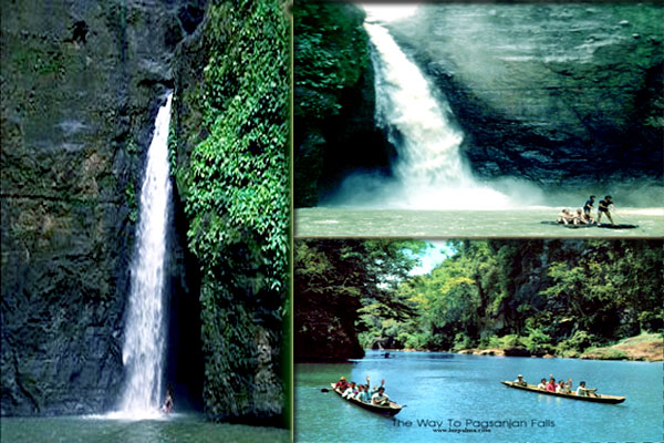
Serving as the capital of Laguna province from 1688 to 1858, the town of PAGSANJAN lies 101km from Manila and is home to a few old wooden houses, an unusually ornamental stone gate – or Puerta Real – and a pretty Romanesque church.

The gate sits on the road to Santa Cruz (Rizal St) and was completed in 1880, while Our Lady of Guadalupe Church, dating from 1690 but remodelled in the nineteenth century, is at the end of Rizal Street. The town’s main claim to fame these days is as the staging point for the dazzling Pagsanjan Falls, chosen by Francis Ford Coppola as the location for the final scenes in Apocalypse Now in 1975.

Most tourists come not for the Hollywood nostalgia value, however, but to take one of the popular bangka trips (daily 7am–5pm; minimum P970) down the fourteen rapids of the Bombongan River. The rapids are at their most thrilling in the wet season; during the dry season the ride is more sedate.

You don’t need to be especially daring to do the trip, though you will get wet, so bring a change of clothes. All ticket sales are supervised by the local tourism office in the municipal building (daily 8am–5pm; T049/808-3544) in the centre of town, opposite the church; ignore touts who try and sell tickets on the street. Most visitors pay P1000 for the ride; boats leave from the bridge behind the building.

It usually takes around 45 minutes to shoot 5.38km through the dramatic gorge; when you get closer to the actual 30m-high falls, you can ride a bamboo raft (balsa) to go directly below the cascade into the cavern known as Devil’s Cave, another thirty minutes or so (this is an additional P250 per head).

MOUNT MAYON - ITS LEGEND AND TOURIST DESTINATION FACTS AND FIGURES BASIC INFORMATION AND TUTORIALS


Image result for MOUNT MAYON
The elegantly smooth cone of MOUNT MAYON (2460m) in Albay province makes it look benign from a distance, but don’t be deceived. Mayon is a devil in disguise. The most active volcano in the country, it has erupted more than forty times since 1616, the date of its first recorded eruption.

The most deadly single eruption was in 1814 when around 1200 people were killed and the church at Cagsawa (see opposite) was destroyed; 77 people, including American vulcanologists, were killed in a 1993 eruption. In August 2006, an “extended danger zone” was enforced but the expected eruption did not occur.

Three months later, however, Typhoon Durian caused mudslides of volcanic ash and boulders on Mayon that killed hundreds. Further eruptions and ash ejections have occurred since.

It’s no wonder the locals spin fearful stories around Mayon. The most popular legend has it that the volcano was formed when a beautiful native princess eloped with a brave warrior. Her uncle, Magayon, was so possessive of his niece that he chased the young couple, who prayed to the gods for help. Suddenly a landslide buried the raging uncle alive, and he is said to be still inside the volcano, his anger sometimes bursting forth in the form of eruptions.

The presence of Mayon results in strange meteorological conditions in and around Legazpi, with the volcano and the surrounding area often blanketed in rain when the rest of the country is basking in unbroken sunshine. The traditional window of opportunity for an ascent is February to April, and even then you’ll have to be well prepared for cold nights at altitude and the possibility of showers.

At any other time of year you could be hanging around for days waiting for a break in the weather. Though the slopes look smooth, it takes at least two days to reach the highest point of the trail, working your way slowly through forest, grassland and deserts of boulders.

Above 1800m there’s the possibility of being affected by poisonous gases, although some guides will offer to take you to 2000m.

There are three recognized approaches to Mayon: via Legazpi’s Buyunan barangay; via the Centennial Forest in Santo Domingo; and via San Roque barangay in Malilipot. The last of these is the most commonly used, starting at 762m above sea level on a ledge where the Philippine Institute of Volcanology and Seismology (PHIVOLCS) research station is located.

Nearby are the abandoned Mayon Skyline Hotel and the Mayon Planetarium and Science Park (free), which has exhibits including photographs of space. It’s worth heading up to this point even if you aren’t climbing Mayon, just to see the views.

MOUNT KANLAON BACOLOD TOURIST INFORMATION BASIC


Where is Mount Kanlaon? How to get to Mount Kanlaon?


Mount Kanlaon
At 2435m Mount Kanlaon, two hours south from Bacolod by jeepney, is the tallest peak in the central Philippines and offers a potentially dangerous challenge. One of the thirteen most active volcanoes in the country, there’s the real possibility of violent eruptions and climbers have died scaling it.

The rim of the crater is a forbidding knife-edge overhanging an apparently bottomless chasm. The dense surrounding forest contains all manner of wonderful fauna, including pythons and tube-nosed bats and locals believe the mountain is home to many spirits.

It also features in Philippine history being where President Manuel Quezon hid from invading Japanese forces during World War II. There are three main routes up the volcano itself. The Guintubdan trail is the easiest and most comon ascent, but even this should not be underestimated.

The usual start point is Guintubdan, where there is basic accommodation at The Pavilion (1) and Rafael Salas Nature Camp (1). From here, although it’s only 8km to the top, the trail is best broken with an overnight stop. The 14km-long

Mananawin trail works best over three days and offers the chance to really get to know the region, while the short, steep Wesey trail is very exposed and only for experienced tropical mountaineers.

Whichever way you choose to ascend, a permit (P300) and guide (P500/day) are mandatory, and a porter (P300–500) might come in handy. The easiest way to make all of these arrangments is through Billy Torres at Next Stop Negros Tours.

Contact Billy as far in advance as possible (ideally a month), and he can arrange everything from permits, guides and porters to tents and meals (climbs around P4500/person excluding transport). Coming from further afield you can also arrange to climb Kanlaon through Dumaguete Outdoors in Dumaguete.

CHOCOLATE HILLS BOHOL TOURIST INFORMATION AND BASICS


What is Chocolate Hills? Where is Chocolate Hills? How to get to Chocolate Hills?


The Chocolate Hills
The surreal Chocolate Hills are renowned throughout the Philippines and one of the country’s biggest tourist attractions. Some geologists believe that these unique 40-metre mounds – there are said to be 1268 of them if you care to count – were formed from deposits of coral and limestone sculpted by centuries of erosion.

Most locals, however, will tell you that the hills are the calcified tears of a brokenhearted giant while others prefer the idea that they were left by a giant carabao with distressed bowels. What you think of the hills will depend largely on the time you visit.

During the glare of the day the light casts harsh shadows and the hills lose their definition. But at dawn or dusk they look splendid, especially during the dry season (Dec–May) when the scrub vegetation that covers the hills is roasted brown, and they really do resemble endless rows of chocolate drops.

Most visitors arrive by tour bus at the Chocolate Hills Complex (P50), where there’s a hotel (T038/416-0199; 2) and a few small souvenir shops. From here there are 213 steps up to the viewing decks where you’ll have the chance to pose for photos riding a broom and wearing a Harry Potter hat.

To get here independently take one of the buses to Carmen (90min; P60) which leave hourly from the Dao terminal in Tagbilaran, often with every inch of bus space taken by locals returning from market with produce.

From Carmen it’s a pleasant 4km walk south up to the hills and then up the steps to the lookout area. You can also hop on a motorbike from Carmen for around P50.

For a different view of the Chocolate Hills, exploring the backroads by motorbike, bike or on foot is definitely worthwhile. Contact Barkada Tours (p.284) for hiking or biking trips.

Alternatively you could head to Sagbayan Peak, northwest of Carmen, where there’s another tourist complex which offers closer-up, quieter views. Take a bus from Tagbilaran to Sagbayan town, then rent a motorbike or walk to the peak complex.

ANILAO BATANGAS BEACH RESORTS BASIC INFORMATION


Some 140km south of Manila, the resort of ANILAO (the name refers both to the village and the 13km peninsula beyond it) is primarily a diving destination, popular with city folk at weekends, when the area can get a little busy.

During the week it’s much more peaceful and you can often negotiate a discount on your accommodation. The best time for diving is March through June; there’s little point in coming just for the beach.

To reach Anilao by public transport, take a bus to Batangas City and then a jeepney west to Mabini or the wharf at Anilao village, then continue by tricycle along the coastal road to your resort. All the accommodation reviewed here is on the road beyond the wharf at Anilao, along the west coast of the Calumpan peninsula.

Accommodation
Aquaventure Reef Club 

Barangay. Bagalangit T02/584-1328, Wwww.aquareefclub.com.
Comfortable, unpretentious resort 3km along the coastal road beyond Anilao. Operated by Manila-based dive outfit Aqua One, it’s primarily a scuba resort, though it also offers island-hopping and snorkelling trips in rented bangkas. Double rooms come with fan or a/c and  ; buffet-style meals are served in a nice open restaurant overlooking the sea.

Casita Ysabel Barangay
San Teodoro T917/610-0005, Wwww.casitaysabel.com.
Preferred hideaway for non-divers (as well as divers), with its Tree Earth Spa and cosy casitas just off the beach (and local reef). Owner Linda Reyes-Romualdez has used Bali as inspiration for the nicest casitas, most of which have ocean views. Meals included.

Dive Solana
BarangaySan Teodoro T02/721-2089, Wwww.divesolana.com.
Along the coastal road beyond the Aquaventure Reef Club, this is a charming and slightly bohemian little retreat popular with divers and owned by Filipina film-maker Marilou Diaz-Abaya. There are a/c and fan rooms (but no TV), some right on the beach, with an ethnic touch, and the rate includes three buffet meals a day. It’s always full at weekends because people keep going back, so book in advance. Prices rise ten percent at weekends.

BATANES TOURIST DESTINATION SERIES - HOW TO GET TO BATANES


Batanes - Treasure of the North.

Almost 100km off the northern coast of Luzon, BATANES is the smallest, most isolated province in the country. This is a memorable place with otherworldly scenery, where doors are rarely locked and welcomes are warm even by Filipino standards.

The people are different, the language is different, even the weather is different. The coolest months (Dec–Feb) can get chilly with temperatures as low as 10°C, while the hottest months (April–June) are searing. For visitors, the islands are at their best from February to May.

Batanes can be idyllic, but it would be wrong to portray it as a tropical utopia as the realities of life this far away from the rest of the world can sometimes be harsh. Petrol and provisions are brought in by ship, which means they cost more, and when typhoons roar in from the east ( July–Sept) it may be impossible for ships or aircraft to reach the islands.

Boredom can set in and locals joke that during the typhoon season the cargo ship brings 50,000 sacks of rice but 60,000 crates of gin.

Only three of the ten islands in the Batanes group are inhabited: Batan – the location of the capital Basco – Sabtang and Itbayat. The native inhabitants of Batanes, the Ivatan, trace their roots to prehistoric Formosan immigrants and latter-day Spanish conquistadors.

Most still make a living from the cultivation of yams and garlic or the raising of goats and cows; if you visit a village during the daytime, be prepared to find that almost everyone is out in the fields. Some women still wear rain capes called vakul, made from the stripped leaves of the voyavoy vine.

The main dialect, Ivatan, includes some pidgin Spanish: “thank you” is dios mamajes and “goodbye” is dios mavidin (if you are the person leaving) or dios machivan (if you are staying behind).

Getting to Batanes
The quickest way to get to Batanes from Manila is on the SEAIR thrice-weekly flight from Manila to Basco. Book well in advance. Unfortunately, the flights are regularly cancelled at short notice so there’s a good chance that you won’t depart on the day for which you have a ticket; you should allow for at least three or four days either side, or more if bad weather is likely.

There’s also a chance that your check-in luggage will not be taken on your flight but instead brought along at a later date. It’s a measure of the appeal of Batanes that it genuinely is worth the hassle.

An alternative – albeit one which also suffers cancellations due to poor weather – is to take a small twin-engine aircraft from Tuguegarao to Basco. Scheduled flights are usually operated by Batanes Airlines (T0915/940-4823 or 0939/198- 6918), but at the time of writing they had been suspended. It was unclear when they would resume.

CAMP JOHN HAY - TOURIST DESTINATION TUTORIALS


What's in Camp John Hey? How to get and where to stay in Camp John Hay?


Named after American President Theodore Roosevelt’s secretary of war, this green space south of the Botanical Gardens used to be a rest and recreational facility for employees of the United States military and Department of Defense.

During World War II the property was used by the Japanese as a concentration camp for American and British soldiers. In 1991 Camp John Hay was turned over to the Philippine government for development into an upmarket country club, with hotels (including The Mansion), a golf course (T074/444-2131, Wwww.cjhhotels.com), private mountain lodges and sundry restaurants and clubhouses.

The expansive, undulating grounds have some nice walks through the pine trees and are also ideal for jogging. Jeepneys can’t enter the park itself, so it’s best to get a taxi from the city centre (P50). If you don’t have a particular destination in mind then ask to be dropped at the entrance to the Historical Core.

Here you can buy a ticket (P50) to see the Bell Amphitheatre, the Ambassador’s Residence (which is still US-owned) and the site where General Yamashita formally surrendered to US forces. At weekends, Filipino families congregate close to the entrance to the Historical Core to enjoy picnics away from the city centre’s traffic.

Also close by is the Tree Top Adventure (daily 8am–5pm; Wwww.treetop adventuresubic.com), where you can try a zip line (P200–300) and abseiling (P150), or join guided walks. If you need something to eat, try the friendly Chocolate de Batirol near the entrance to the golf club.

Alternatively head over to the Mile Hi Center where you will find duty-free outlet stores, several restaurants, a hotel and a handy ATM.

CATANDUANES TOURIST SPOTS AND DESTINATIONS BASICS


What is in Catanduanes?

The eastern island province of Catanduanes is ripe for exploration, a large, rugged, rural island with mile upon mile of majestic coastline. It has still barely felt the impact of tourism, although with eight flights a week from Manila and improvements to the main road around the island this is slowly changing.

In fact surfers have known about Catanduanes for quite some time, attracted to the big waves off Puraran Beach on the wild east coast. There are also several good beaches within easy reach of the capital Boac, as well as other attractions like the immense caves in Lictin, while the undeveloped west coast offers the opportunity to blaze a trail into areas few travellers see. Most of all Catanduanes is a friendly, down-to-earth place to hang out for a few days, as long as you are willing to adjust to a slower pace of life and travel.

It isn’t all good news though. Filipinos think mostly of bad weather when they think about Catanduanes, lying as it does on the exposed eastern edge of the archipelago smack in the middle of the “typhoon highway”.

Unless you are a surfer the best time to visit is from March to June, when the chances of rainfall are slight and the wind is less wicked. During the wet season ( July–Nov) the island can be hit half a dozen times by typhoons, causing extensive damage to crops and homes and sometimes loss of life.

Getting around Catanduanes
Hiring a car with a driver is a good if expensive way to see the island; try the drivers at the airport, visit the tourist office or simply ask your accommodation to arrange it. For about P2000–3000, for instance, you can get a return trip to Puraran Beach including waiting time; for a full day exploring expect to pay P4000–5000.

Otherwise, buses run from Virac up the east coast to Bagamanoc (90min; P100) or Pandan (3–5hr; P150). The going is significantly slower on the west coast road. Jeepneys are commonly used for shorter distances, such as from Virac to the nearby municipalities of San Andres, San Miguel and Bato; tricycles will also make these trips at a higher rate. Some locals offer trips around the island on their motorcycles for P1000–2000; the journey to Puraran would cost around P300–500.

THE MALACANANG PALACE AND MUSEUM - TOURIST DESTINATION


How to get to the Malacanang Palace and Malacanang Museum?

Malacanang Palace is the home of the President of the Philippines. It tells many history, and a significant part of Philippine history. It like the White House of the United States of America.

Home of the governor-generals and presidents of the Philippines since the 1860s, the Malacañang Palace is a fittingly grand and intriguing edifice, well worth the minor hassle involved in arranging a visit.

Much of the palace is permanently off-limits to the public, but you can visit the wing that houses the Malacañang Museum (Mon–Fri 9am–4pm; P50; T02/784-4286, Wwww.president.gov.ph) by making an appointment at least seven days in advance.

You’ll need to email or fax a letter of request to the palace, stating your name, preferred date and time of visit, and attaching a photocopy or scan of your passport; call first to confirm the latest procedure.

You can also join a tour run by Ivan Man Dy of Old Manila Walks (T0917/329-1622, Wwww.oldmanilawalks.com), which saves you the bother.

The Malacañang occupies the site of a smaller stone house dating from 1750. In 1825 the Spanish government bought it and, in 1849, made it the summer residence of the governor-general of the Philippines.

After the governors’ palace in Intramuros was destroyed in the earthquake of 1863, the move to Malacañang was made permanent and the property was extended several times over the years.

The museum occupies the beautifully restored Kalayaan Hall, completed in 1921, and traces the history of the palace and of the presidency from Emilio Aguinaldo to the present day.

The palace is in J.P. Laurel Street in San Miguel district, a short taxi ride east of Intramuros and Quiapo.

MOUNT ISAROG NATIONAL PARK CAMARINE SUR PHILIPPINES BASIC INFORMATION


HOW TO GET TO MOUNT ISAROG?

Mount Isarog National Park covers forty square kilometres in the heart of Camarines Sur, about 40km east of Naga. At its centre stands Mount Isarog (1966m), the second highest peak in southern Luzon and part of the Bicol volcanic chain that also includes Mayon. Isarog is considered potentially active, although it is not known when it last erupted.

The park is relatively easy to reach, but once on the lower slopes of the mountain you may feel as if you have stepped through a portal into the Jurassic Age. The jungle is thick and steamy, and the flora and fauna are among the most varied in the archipelago.

Long-tailed macaques and monitor lizards are a pretty common sight, while with a little luck you may also spot the indigenous shrew rats, reticulated pythons and rare birds such as the bleeding-heart pigeon, red-breasted pitta and blue-nape fantail. Reaching the summit takes two days of strenuous climbing.

At the top are two craters, the lower of the pair containing a number of fumaroles steaming with sulphurous gas.

A number of paths on Isarog’s lower slopes lead to waterfalls – including Mina-Ati, Nabuntulan and Tumaguiti – all of which are surrounded by thick rainforest and have deep, cool pools for swimming. The easiest waterfall to reach is beautiful Malabsay, a powerful ribbon of water that plunges into a deep pool surrounded by forest greenery. It’s a delightful place for a dip. There are also some hot springs in Panicuason (admission P200).

The best time to trek is between March and May, but it is possible at other times weather allowing; September to December is particularly wet. The most commonly used route to the summit takes three days and is called the Panicuason trail, starting at the barangay of Panicuason.

There are also four other recognized routes on the mountain: the PLDT Trail (2 days), Curry Trail (3 days), Patag-Patag Trail (3 days) and Hiwakloy Trail (4 days). They vary in character and difficulty.

There’s a Protected Area Office (contact Yolda Abante on T0910/482-4615) at the park entrance used for the Panicuason trail, where you can get a permit (P80); if you are taking a different trail then you should instead request a permit at the Mount Isarog Protected Area Superintendent Office, 35 Panganiban Drive in Naga at least three days in advance.

A good place in Naga to glean additional information about the climb is the Kadlagan Outdoor Shop (T054/472-3305, Wkadlagan.i.ph), 16 Dimasalang St, where you can rent basic equipment. You will also need to secure the services of a local guide (P250–400/day); ask at Kadlagan, the Naga City Visitors Center or the Protected Area Office.

To get to Panicuason, take a jeepney (P20) from close to the market in Naga. It’s a four-kilometre walk from Panicuason along a well-marked trail to the ranger station, Malabsay Waterfall and the entrance to the park proper.

There are no jeepneys from Panicuason back to Naga after 4pm, so keep an eye on the time. If you get stuck you’ll have to pay to rent one privately, usually costing around P1000.